Mid King Biv Trip Report
This trip report is really more a cautionary tale of overconfidence and inexperience leading to a challenging Tararua overnight trip to Mid King Biv.
Started: 11am from Holdsworth Carpark
Finished: 6:30pm the next day at Holdsworth Carpark
Travel Times:
Day 1:
- 2 hours to Atiwhakatu Hut (break)
- 1 hour from Atiwhakatu Hut to the swingbridge over Atiwhakatu Stream
- 20 minutes to Baldy turnoff
- 1 hr 10 minutes to bushline
- 40 minutes to Baldy summit
- 1 hour to South King
- 2 hours to Mid King Biv (< 1 km)
Total: 9 hours
Day 2:
- ~4 hours from Mid King Biv to Barton Track (South Mitre Stream bridge)
- ~3.5 hours from Barton Track (South Mitre Stream bridge) to Atiwhakatu Hut
- ~2.5 hours from Atiwhakatu Hut to Holdsworth carpark
Total: 10 hours
Day 1: Holdsworth carpark to Mid-King Biv via Baldy
This trip had been planned carefully to fit in around family commitments betweeen Christmas and New Years, so having found a couple of days spare, me and my tramping buddy for this trip were locked in and ready to go. The original plan was to travel up to Atiwhakatu Hut and either stay at Jumbo or carry on past to McGregor Biv, returning the next day over the Broken Axe Pinnacles, down Baldy, back to Atiwhakatu, and out.
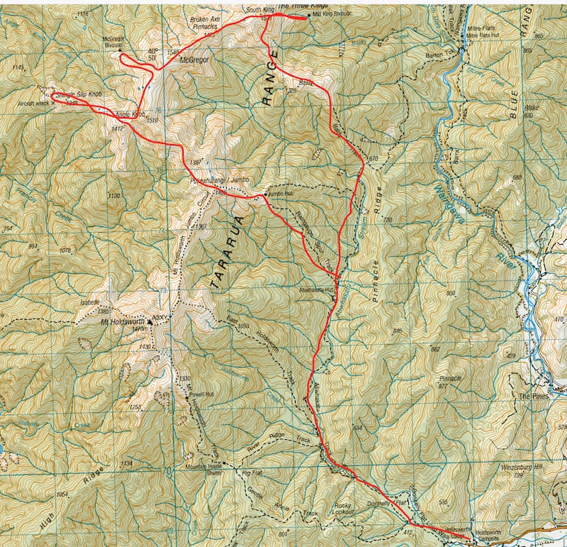
We met in Carterton at 9am, to sort out gear, supermarket shopping and last-minute coffees and food. The weather forecast promised showers for the first day, with a slight improvement the next. Facing a high liklihood of it being a fairly wet and miserable day, we revised our plans, opting to flip the route around to instead aim for Mid King Biv, stay overnight there, and try and get all the way across the Pinnacles and past Jumbo to head out the next day. Our plans were somewhat influenced also by very full hut bookings for Powell, Jumbo, and Atiwhakatu, which meant that we were unlikely to have much luck finding a bunk in any of these huts.
By 10am, we had finally organised ourselves and hit the road to Holdsworth, arriving at 10:45 and signing in on the intentions book at Holdsworth Lodge by 11am. We made steady time into Atiwhakatu, arriving after 2 hours for a lunch stop. The hut was looking suspiciously empty for the time of day considering it was supposed to be fully booked, with just one group in, but we scoffed down some wraps and leftover Christmas ham before continuing up the valley. From this point on, this was new track for me. The weather was fairly grey, with drizzle or showers most of the time.
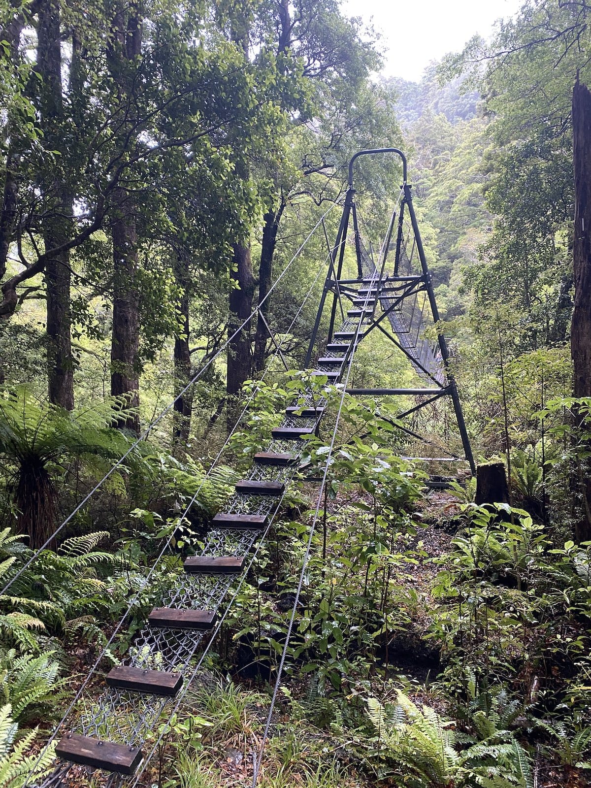
The track from Atiwhakatu Hut to Mitre Flats Hut is reasonably well travelled, but obviously doesn’t receive the love and attention the Atiwhakatu Hut track receives (the track between Holdsworth and Atiwhakatu Hut was significantly rebuilt a few years ago to make more accessible for family groups). It sidles along beside Atiwhakatu Stream, dodging up and down the bank a couple of times to avoid slips and bluffs. After an hour, we reached the swingbridge over the stream.
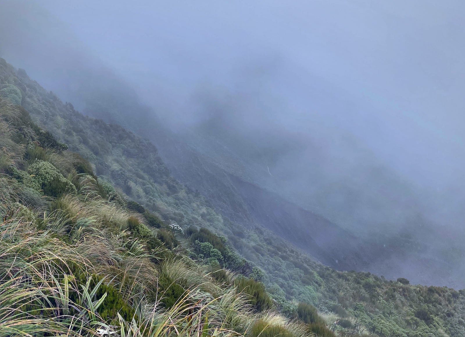
After crossing the stream, the climbing began! The travel so far had been wet, but as flat as it ever gets in the Tararuas. From this point on, we had some solid climing to do from about 550m to Baldy at 1325m, and then on to South King at 1531m. The climb up to the bushline at Baldy wasn’t too bad - pretty similar to most other Tararua climbs - straight up the spur, with the contour lines on the topomap determining whether it was clambering or just puffing up steadily with the occasional breather. In this time, we travelled up through Beech, then mossy mountain beech, before this to thinned out and we arrived at the bushline just slightly after the posted time of 1 hour. As we’d approached the bushline, we’d moved properly into the cloud, so it was fairly steady drizzle and mist now. The posted time to Baldy at the intersection we’d left behind near Atiwhakatu stream is only to the bushline, and from here it was tops travel - no times, just distance to tick off. Travelling up through the tussock and mist, it took us another 40 minutes to reach the summit of Baldy - or at least a piece of DOC caution tape tacked to a wooden batten, what I assumed to be the summit.
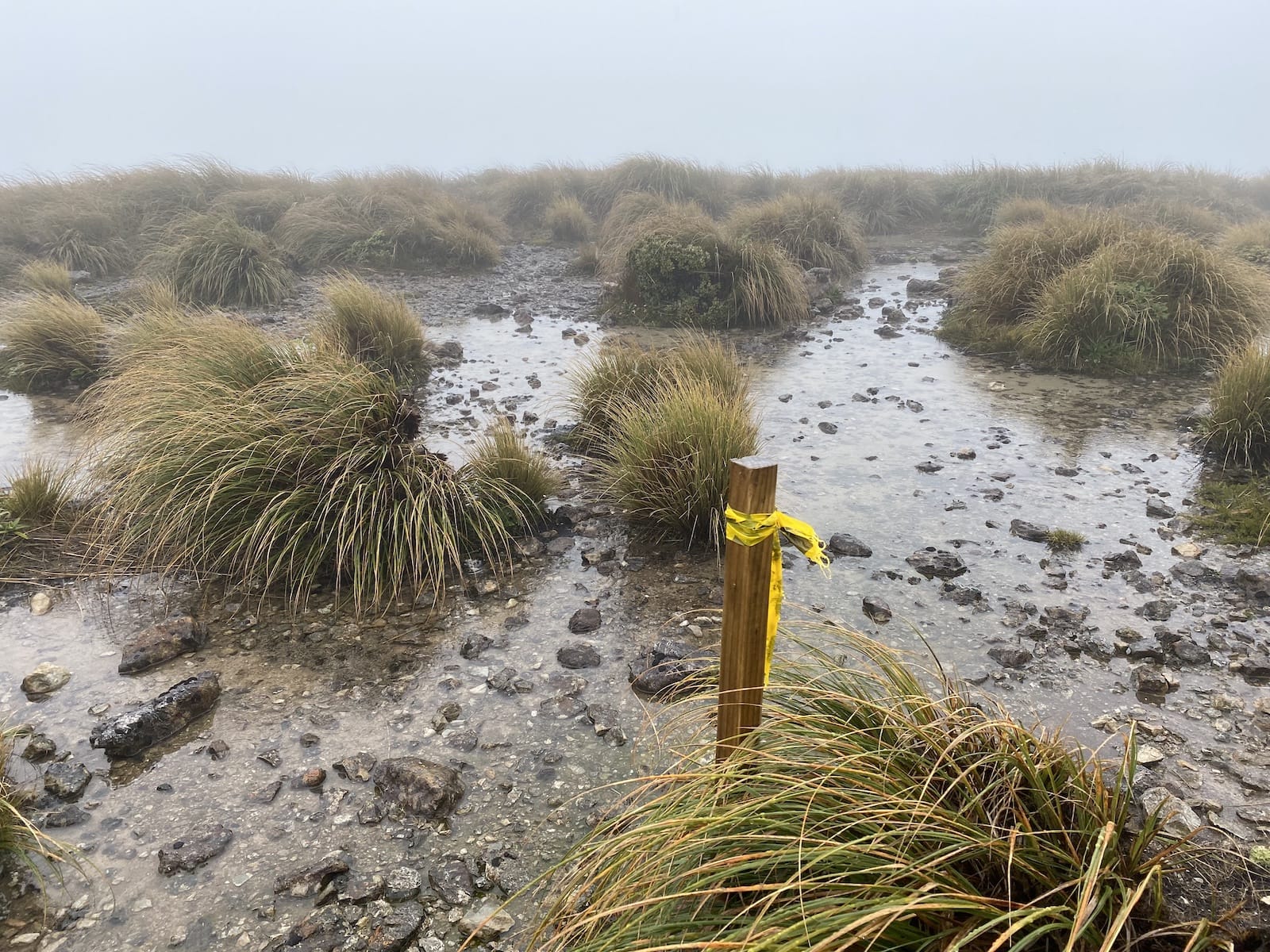
Something that I noticed on this trip, particularly around the tops, is that the route is generally not poled in this area. Previous tops travel I’ve done in poor visibility around Tabletop/Kime Hut, and even Powell/Holdsworth has felt much safer since either warratahs or blue plastic poles mark the route there, and the poles are spaced so as to be reasonably visible even in poor conditions. On this route, it was largely a case of following the worn trail and the topomap, with an occasional cairn to let us know we were on the right trail. This generally worked out for us, though it requires more attention than following poles, and we did have a bit of trouble just after the Baldy summit where some erosion made it hard to pick out the route. In clearer conditions, this would be easier since the ridgeline would be visible, but in the mist it was quite hard to gauge whether we were following the crest of the ridge and not dropping off.
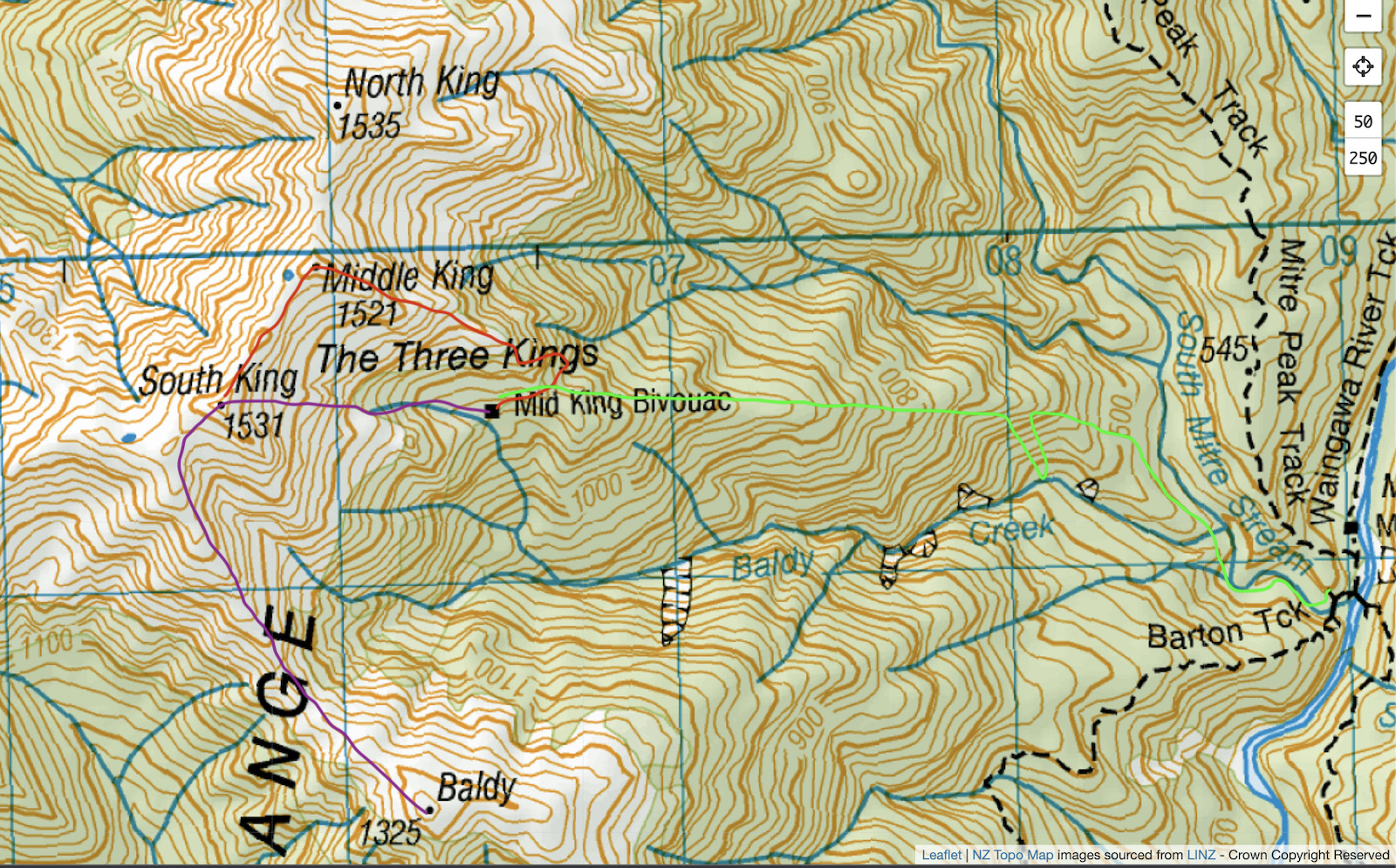
With a couple of craggy bits to negotiate, it took us about 45 minutes to reach the South King Tarn where the route from Baldy we were on joins the route coming North from Jumbo via the Broken Axe Pinnacles, our planned route for the following day. By this time it was after 5pm, so while we still had some day to work with, we were in a bit more of a hurry to reach the biv and dry out a bit, so turned to the right to carry on up to the top of South King proper, reaching the top after another 15 minutes or so.
It was here that we made our major navigational blunder, attempting to follow a GPS track that I had found while researching for the trip. The source of my research, a Wilderness magazine post seemed to indicate that the route to the Biv dropped directly off South King to reach what looked on the topomap like a spot where the bushline was slightly higher. This route was tempting, since it saved us a bit more travel along the ridgeline and got us heading straight to the hut, hopefully into the shelter of the beech forest faster than other options. If we’d stopped for a little longer and made use of the cell reception we’d had since halfway up Baldy, we would have found that while this source does suggest a route off South King, several other sources instead recommend the spur from Mid King itself, just a bit further north. Unfortunately, we made the mistake of seeing the hut was only about a kilometer away, and went for it, dropping off South King towards Mid King Biv.
At first, travel was pretty easy. After a day of drizzle, the tussock was slippery, with the occasional spiky spaniard grass eliciting pained exclamations, but we were losing the altitude we needed to reach the hut quickly. We then started passing the occasional leatherwood shrub, which gradually became less and less occasional, until we were having to pick a route between them.
Leatherwood has a particular reputation around the Tararuas as an extremely hardy, thick leaved shrub, growing close to the ground, but becoming larger and larger closer to the bushline, around 2-3m. It has a particularly annoying springiness to it - it is difficult to break branches off leatherwood or even to push through, since any resistance is pushed right back at you.
The descent on the tussock had been steep, but manageable, but now we faced some challenging decisions. The leatherwood was now all around us, and from what we could see, was getting bigger and thicker, making it hard to see where we were putting our feet. While the mist restricted our visibility, we could see on our left hand side that the ground was dropping away sharply. In front of us, it was looking like it might do the same, and we edged forward to see if we could see a safe route down.
At this point, we had the first of several decision points about whether to carry on or climb back up to the main ridge and start again. Looking back, given the fact we had any doubt about our route, climbing back up would have been the correct move - but at the time, we were wet, and tired. The climb back up through slippery tussock to meet a ridge where we still wouldn’t definitely know where to go was daunting. We chose to carry on, assuming we’d be able to continue picking a route through. We looked on the map and reminded ourselves that the hut was not far away, and that the green on the map surely represented easy-travelled, sheltered beech forest.
Having chosen to continue down the slope, we found a spot that was the best of a bad lot. There really weren’t any safe options that we could see, and looking back, this was a really bad call for us to make, but we found a spot that looked like it could be clambered down, around 3 meters of maybe 75 degree slope, and set off. I went first, and managed 2 footholds before I ran out halfway down. By then of course, I was committed, and then second foothold sort of changed it’s mind about being a foothold anyway - I slid down the rest of the slope on my front, landing quite heavily. Fortunately for me, I landed flat on my feet - on an angle, I think I probably would have been looking at least at a sprain.
The only good thing about having done that drop is that with a different perspective, I could look for better route down for us to rejoin at the bottom of the slope. This meant that we didn’t both need to do as much of a slide to reach the bottom.
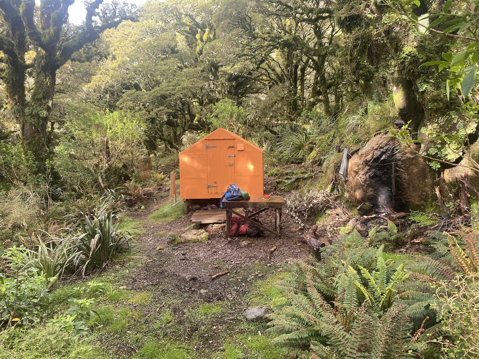
After this, the travel continued to become more and more challenging. We felt increasingly more trapped in our situation now, feeling that it was unlikely we’d get back up that slope. We continued to do our best to follow the topomap towards the hut, but constantly had to stop to try and scout the best route through the leatherwood, which had become much taller and larger as we’d dropped down another contour line or two. This travelling was particulaly tiring. We knew we were close to the hut, but not imminently so. The leatherwood grew very densely, concealing drops and holes. In places, the we tried to go under or through the leatherwood, causing cuts and scratches. In other places, the leatherwood was so dense that we would try and crawl over the top of it. Despite the topomap showing a single stream that led past the biv, after the wet day we’d had, we continued coming across other small streams, any of which could have been the one to follow. We crisscrossed the larger 2 of 3 streams several times trying to find clearer ground, and eventually ended up dropping into the largest stream for the final couple of hundred meters, splashing down the stream, ducking under or clambering over the leatherwood which at times completely tunneled in the stream, and a couple of times when the water was too obstructed, climbing back into the leatherwood to work around the obstacle. We reached the biv at 8pm, not long before dark, having approached it from the back via the stream. Fortunately, this biv, like many ex-NZFS huts, is painted bright orange.
This part of the day was both incredibly challenging and humbling. It took us over 2 hours to travel around a kilometer to the biv, and absolutely pushed our endurance and fitness to the limit. I don’t feel that we were ever in life-threatening danger (we carried a PLB for that scenario), but we were certainly beginning to reach the point where we would have had some difficult decisions to make around whether we continued to try and reach the shelter of the biv, or whether we should shelter where we were, and try again in the morning. The root cause of us ending up in this situation was essentially a failure to properly research and understand the best route to the hut, to make rushed decisions influenced by desire to get to shelter and hot food, and to not understand the characteristics of the Tararuas. What we thought was a higher bushline in green on the map, was of course leatherwood and other mountain shrubs. Other routes, such as the spur from Mid King, show clearer travel further down towards the biv, but instead we headed right for the green on the map assuming it would be sheltering forest, and ended up stuck in a basin of leatherwood as a result. We had several opportunities where we could have turned around, returned to the ridge, and probably found the actual route down, but since we’d already had a long day, as soon as we started dropping altitude, we felt committed to continuing - sunk cost strikes again.
We were able to use the 1 bar of cell reception at the biv to advise our contacts that we had arrived safely, but tired. Having expended significant energy getting to where we had, we discussed and agreed that to travel over the Broken Axe Pinnacles with another long, exposed day before reaching Jumbo Hut would be pushing our luck and stamina. We would instead drop down to the valley near Mitre Flats Hut, and cross a saddle back to Atiwhakatu Hut to complete a loop. We had a quick dehy meal, a hot drink and crawled into the 2-person ‘dogbox’ biv to get some sleep.
Day 2: Mid King Biv to Holdsworth Carpark
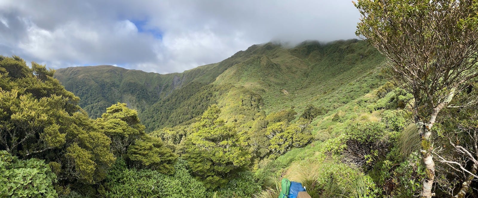
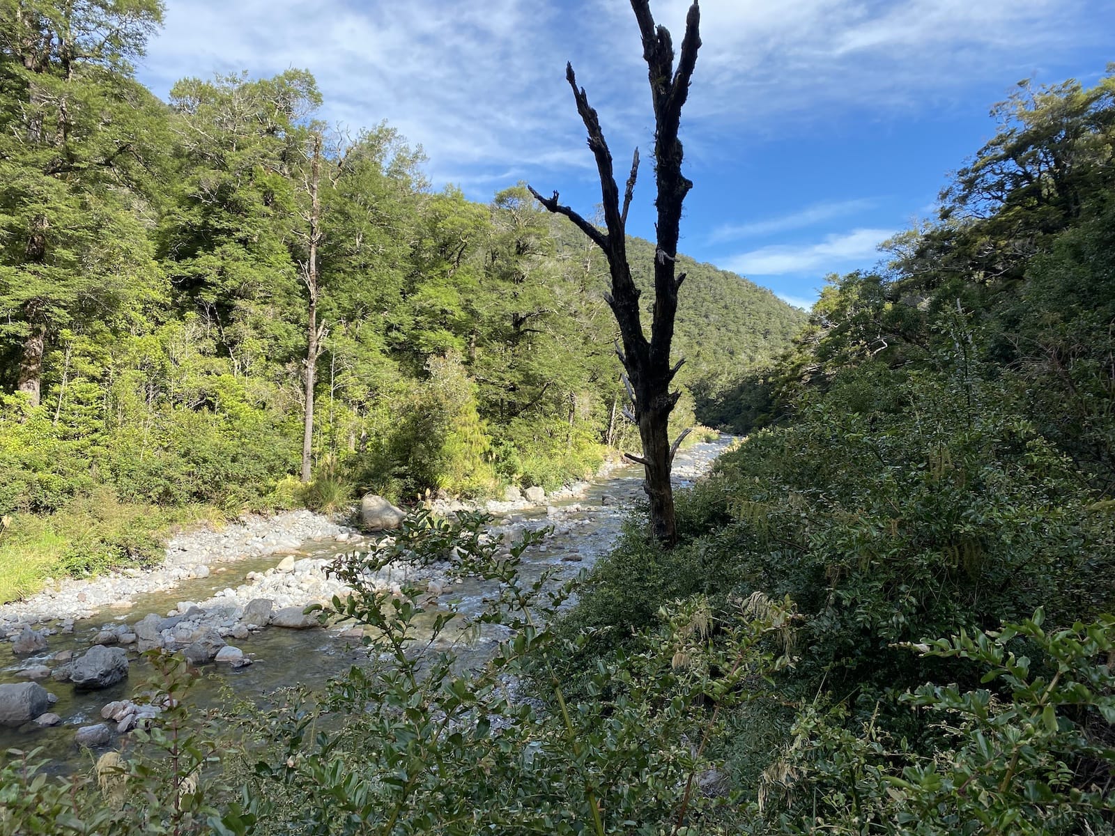
In contrast to the misty and rainy day we’d had previously, the weather was looking much better in the morning, with the sun shining through the trees, giving everything a very gold and green look. We knew we had a long day ahead of us - we were anticipating it taking 2 hours for us to drop to the swingbridge near Mitre Flats Hut over the South Mitre stream, then 3 hours to get from there to Atiwhakatu Hut, and another 2 hours or so out - 7 hours total. We had a quick breakfast and coffee, and hit the track. I was cursing our navigation error from the previous day as we followed a clear route marked with orange triangles for 10 minutes to the bushline. From here, the triangles were replaced with pink tape, but the route was still clearly obvious, and it looked as though if we’d dropped off the spur from Mid King instead of South King, we would have had a much easier time.
As we reached the bushline, we looked up towards the Kings, and across towards the Pinanncles, and had a quick checkin. Should we go over the ridge route to Jumbo after all? In the end, we opted to continue dropping to Mitre Flats, for a few reasons:
- We’d already been in touch with our contacts to advise we were going back through the valleys. Changing our minds would require us to stop, plan out our route a little, and get in touch with them again.
- Even though it was quite sunny where we were, the cloud was still covering the main ridge. Neither of us had travelled that route before, and I knew that the Broken Axe Pinnacles in particular are narrow and can be a bit technical, especially in poor visibility.
- A good night’s sleep had restored us somewhat, but we were still feeling pretty battered from the previous day. It seemed best given some poor decisions the previous day to take the less risky option of travelling down and out through the valley.
- We considered seeing if we could arrange a pick up at The Pines, where the most direct route from Mitre Flats Hut emerges. This would require a bit of coordination with our contacts in 1-2 bar cell coverage, and would still require us to get to Mitre Flats and then out, which is signposted as 4 hours, plus another hours drive to reach Holdsworth carpark. We decided that the overall travel time for this option meant that it wasn’t partciularly compelling since we were tired, but not injured, and getting ourselves back to the cars under our own power meant we could travel to our own schedule. If either of us had been even mildly injured, we would have taken this option, since it would have been the fastest way out.
The track from Mid King to Mitre Flats isn’t on any maps, even the Topo50 series. The hut intentions book made it clear that it’s quite a well-travelled route though, with many people coming up from Mitre Flats on a day trip. My primary concern for this route was that we wouldn’t be able to find the track, but it turned out to be fairly obvious where to go. We did miss the first few meters and overshot, but seeing a cairn on the other side of some leatherwood, were able to deploy our new scrub-bashing skills to join the track. The track is taped, but very intermittently, so we had to pay attention to where we were heading to make sure we were still following the track. This was easier at the start, while the beech forest was still quite stunted, and the path through the moss was quite obvious. As we got further down into the bush, things got more complicated, with a lot of dead ends and spots where treefall had concealed the line of the track. It was a relief to spot a piece of tape or a cairn every now and then to let us know we hadn’t gotten badly lost.
When we did lose the track, we had the advantage of being on a spur, meaning we could traverse across the top of the spur until we found the most promising-looking worn route, which we would follow until we found a cairn or tape. The spur route effectively heads straight down the spur, dropping from about 1100m to just under 500m by South Mitre Stream.
The aim is to meet the South Mitre Stream where Baldy Creek joins it. We mostly managed this aside from a diversion where we left the spur too soon, and ended up down at Baldy Creek about a kilometer from South Mitre Stream. We fossicked around a bit and contemplated going down the stream, but in the end decided to climb back up the 50 or 60 meters to rejoin the spur. After we eventually reached the point where stream and creek intersected, we started heading down beside the stream towards the swingbridge on the Barton Track. This travel wasn’t too difficult since it was reasonably flat and open beside the stream, but we didn’t find a particularly clear route at any point, and lost it completely just 100m or so from the swingbridge. I suspect it climbed up to join the Barton Track after the bridge, but since we could see the bridge, we dropped into the stream and crossed the stream to avoid a small bluff the bridge was built onto, and re-crossed the stream via the bridge.
Overall, we expected this section of track to take us 2 hours, and it had taken us 4 hours. Being used to front-country type travel, I think this is probably the longest stretch of non-triangle-marked track I’ve done, and it was surprisingly time-consuming and stressful to make sure that we were following the spur and not dropping to one side or the other too early, and to regain the track when we left it, which we did many times (usually only by 10 meters or so). Probably a more experienced tramper wouldn’t find this route difficult, since the bush is quite open and easy to travel through, but I hadn’t realised how dependent I was on following from one marker to another. By the time we joined the Barton Track and stopped for a break beside the bridge, I wasn’t feeling great - we were well behind schedule on what we already knew was going to be a fairly long 7 hour day, and we still had a lot of ground to cover.
We had considered stopping in at Mitre Flats Hut for a break, which was only a couple of hundred meters away in a clearing. Given we were “behind schedule”, we skipped this option, and started trudging. One of the downsides of the Barton Track which runs between Mitre Flats and Atiwhakatu Huts is that it goes up and down - a lot. While we’d dropped on the spur down to 400m, we had to immediately climb back up to 600m, and traverse approximately along this contour (I say “approximately” because in reality the track was always going up and down by 20m or so, never flat), before dropping 100m to cross a stream, then climbing 200m to meet the Baldy turnoff we’d left yesterday just short of 700m. Reaching the Baldy turnoff, psycologically, was a big boost - it meant a lot to have closed the loop and now be retracing our footsteps over ground we’d covered - we knew what was coming, and more importantly, knew that Atiwhakatu Hut was only about 1.25 hours from the turnoff. We made slow progress between the Mitre Flats swingbridge and Baldy turnoff, about 2.5 hours (signposted time is 1.75 hours). Largely this was due to being pretty tired, and needing a lot of mini-breaks and breathers. After reaching the Baldy turnoff, we gained a little speed and stumbled into Atiwhakatu Hut for lunch about 3:45pm.
At Atiwhakatu Hut, we took a little time for break, and treated ourselves to the last of our dry clothes we’d been saving for the last stretch. I’d considered a longer stop at this hut - perhaps an hour or two - to rest up a bit before continuing, but after having a bit of food, decided to carry on and get it done. We left just before 4:30, and immediately noticed the easier travel on the well-graded and gravelled Atiwhakatu Track, which served as a relatively gentle 2-and-a-bit hour cooldown out to the carpark, which we reached at 6:30pm, just in time to get a message out before my 7pm due-out time I’d arranged earlier in the day at the Baldy turnoff where we found a little cell coverage. Having already split the gear up back to their respective owners while stopped at Atiwhakatu, we were pretty relieved to each jump in our own cars and head back home, after a humbling trip, and one that to me has served as a reminder about how quickly risk factors can add up to quite a difficult situation and trip.
Retrospective
In retrospect, there are a number of factors that I will consider in the future:
- The weather forecast was for showers through the day. This meant that we were not going to stay dry. Given we were already looking at a trip that was going to be reasonably challenging for our skill level, we could have considered an alternative destination or route.
- While Atiwhakatu Hut and Jumbo were both booked, we had camping stuff with us, including a tent. We had mostly ruled out staying at Jumbo because of the bookings, when actually we could have probably either camped or found a bunk, and this trip would have still allowed us to venture onto the tops, but in a less remote area more in-line with our skill level. The quietness of Atiwhakatu Hut on the first day could have prompted us to change our trip plans and head to Jumob, but we already felt committed to what we had decided.
- When we reached South King, I had a couple of different webpages downloaded to my phone to refer to, but I picked the first of these and stuck with it since it included a route to follow on a topomap. As it turns out, this route wasn’t the best way to go - I wonder if it was drawn from memory after the trip, or if that group just didn’t mind travelling through the leatherwood as much as we did. If I’d stopped and properly considered all of the information I had on hand rather than rushing to reach the biv, there’s a high chance we would have continued to Mid King and probably found a clearer route down.
- Navigating our own way along an unmarked route through the bush takes much longer than just following a track, even with similar distances. The fact that this section took twice as long as we thought it would was disspiriting and exhausting, and made the rest of the day much harder to get through. If we’d been able to accurately forecast our travel time for the day, and given the reasonably good weather conditions when we left the biv, we probably would have chosen to go back up and along the ridge to Jumbo, or even back down Baldy. We still would not have had good visibility, but tops travel time is easier to assess, and we would have reached Atiwhakatu Hut after around 3.5 hours via Baldy, or Jumbo Hut after perhaps 4 or 5 hours.
Overall, I learned a lot from this trip about where my comfort level lies, but also the endurance I have when necessary. We’ve not been put off future trips, but have already agreed that given our skill and comfort levels, our next trip in this area will be to head to Jumbo Hut and proceed out to the tops from there with a hut at our backs, rather than overextending ourselves to reach a remote shelter.